2 DEATH VALLEY RANGES GUIDE NO. 2.14
CORKSCREW PEAK 5804 FEET CLASS 2
MILEAGE: 275 miles of paved road
DRIVE: There are three main routes that can be taken to the parking area for Corkscrew Peak.
1) From Stovepipe Wells, CA drive 6.2 miles E on State Highway
190 to the signed road to Scotty
's Castle.
Turn left (N) here and drive 0.6 miles to the signed, paved Daylight Pass Road heading toward Beatty, NV.
Turn right, driving 6.6 miles to a signed road fork at Hell's Gate (DVNP Information Board here), then 0.9
miles further up the Daylight Pass Road, pulling off the pavement and parking on the dirt shoulder adjacent to
a wash bank. If you go too far, you'll come to a road sign pointing to Corkscrew Peak. Simply turn around
(back toward Death Valley) and drive 0.25 miles to the parking spot.
2) From the Visitors Center at Furnace Creek, CA drive about 11 miles N on State Highway 190 to the signed,
paved
Day
light Pass Cutoff Road toward Beatty, NV. Turn right and follow this road 10 miles to a signed
road fork at Hell's Gate. Bear right onto the Daylight Pass Road and drive 0.9 miles, parking on the dirt
shoulder adjacent to a wash bank.
3) From the intersection of US Highway 95 and State Highway 374 in Beatty, NV drive 18.4 miles W on
State Highway
374, pulling off the pavem
ent and parking on the dirt shoulder adjacent to a wash bank. This
parking spot is 0.25 miles past the road sign pointing to Corkscrew Peak and 0.9 miles before the signed road
fork at Hell's Gate.
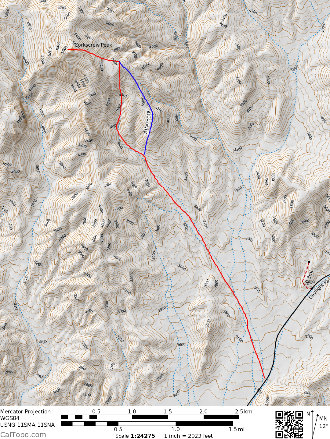
CLIMB: From the parking spot the peak is obvious at a bearing of 325°. Hike up over the
wash
bank directly
toward the peak, continuing for just over 2.0 miles on gently upward sloping terrain to the base of the
mountain. At 3700 feet elevation the wash you'll be hiking in narrows and presents its only obstacles; a 15
foot high, Class 3 dry waterfall followed by a somewhat easier 10 foot dry waterfall. Either climb these falls
or bypass them on high ground to the left. (A route variation here goes NNE up the ridge over point 4400+,
then NW along the ridge to the 5080+ foot saddle at UTM 002690. See topo map.). Just above the second
dry waterfall the wash forks. Take the right branch and hike 0.5 miles to a wash fork at about the 4100 foot
elevation level (En route to this fork be looking upslope to your left for a black rock outcropping at 4300 feet
with a large hole through it. It's a good landmark to assure that you're on the right route). Bearing left at this
fork, spot the small notch at bearing 335°, just left of the prominent reddish-brown and black pinnacle on the
skyline ridge. Follow the wash and slopes above you through this notch to a saddle at 5080+ feet (UTM
002690). At the saddle, turn left (WNW) and hike uphill (faint trail here) for 0.4 miles to the "break" in the
summit cliffs on the N side of the peak. Follow a game trail from here up to the top.
ROUND TRIP STATS: 3300 feet elevation gain, 7 miles, 6-7 hours
SIDELINES
1. This peak is located within the boundary of Death Valley National Park.
2. There is no camping near the trail head. There are established campgrounds at Stovepipe Wells, and
Furnace Creek, otherwise camping may be found in Beatty, NV. Contact DVNP for information on
primitive camping within the park.
Revised 11/6/17
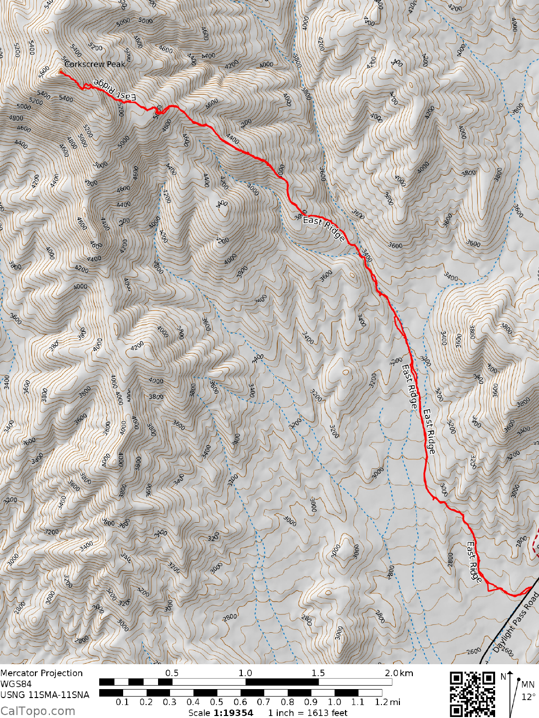
Route B: Starting at or near the Corkscrew Peak sign (room for one vehicle there), head west into the
wash, then head directly for the peak. There is a well cairned route through the wash with a faint to
good use trail. It will generally keep to the right side of the wash as it heads to a narrowing ahead.
When you enter the narrow part of the wash, there will be a line of rocks and cairns pointing to an
exit from the wash on the left. As you exit the wash you will be at the base of the ridge you will
follow all the way to the summit. The use trail is well established and is quite easy to follow. It will
intersect the standard route at the saddle mentioned above at approximately 5,080' of elevation. Continue
on to the summit.
Round trip stats: 7.9 miles round trip, six to seven hours.