2 DEATH VALLEY RANGES GUIDE NO. 2.11
NEEDLE PEAK 5803 FEET CLASS 2
MILEAGE: 193 miles of paved road, 18.6 miles of excellent dirt, 12.8 miles of poor to 4WD dirt road.
DRIVE/ROUTE A/WESTERN APPROACH: Follow the Manly
Peak Drive/Western Approach directions to
Mengel Pass. From Mengel Pass, follow the road down into Butte Valley 1.8 miles to a fork near the
Geologist's stone cabin. Bear right at this fork and go 0.2 miles to a junction. Turn right here and drive about
1 mile toward Willow Spring to the DVNP Wilderness boundary. Park. NOTE: See Manly Peak, CA 7.5
minute topo (Guide No. 2.10) for details of roads in this area.
5HFHQWWULSUHSRUWVLQGLFDWHWKDWWKLVURDG
PD\EHLPSDVVLEOHWRDOOEXWWKHEXUOLHVW:'YHKLFOHV'ULYHDW\RXURZQULVN
DRIVE/ROUTE A/EASTERN APPROACH: Follow the Manly Peak Drive/Eastern Approach directions to
the intersection of the Geologist's cabin road in Upper Butte Valley. This point is 11.1 miles from the Warm
Springs Mining Camp. Turn left here and drive about 1 mile toward Willow Spring to the DVNP Wilderness
boundary. Park. NOTE: See Manly Peak, CA 7.5 minute topo (Guide No. 2.10) for details of roads in this
area.
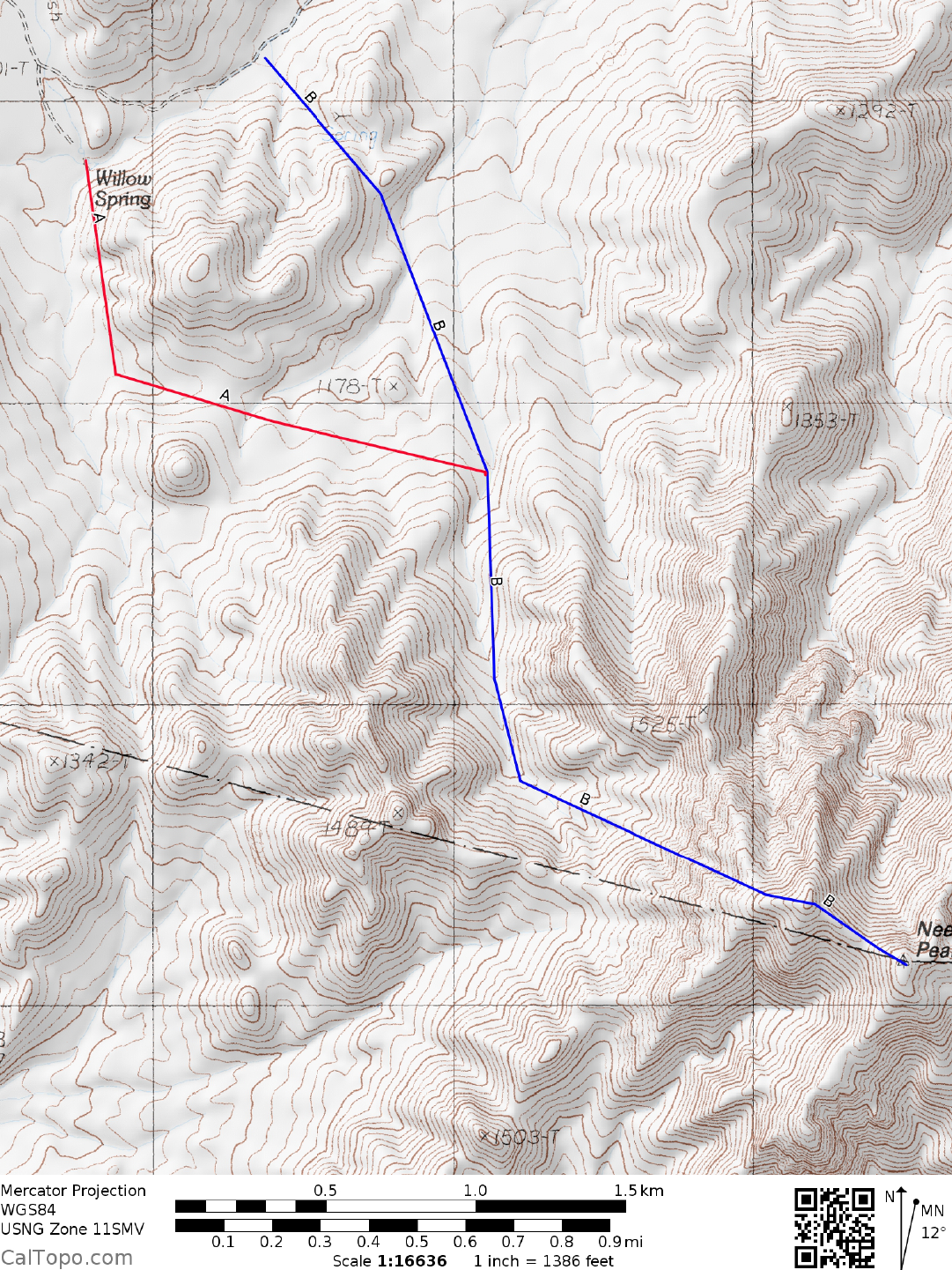
CLIMB/ROUTE A: Hike SE on the road about 0.75 mile to Willow Spring. Head S from the spring about 0.5
miles, following any convenient burro trail along the W side of hill 1250+. Once past the hill, bear E to a
broad, flat saddle about 0.4 miles ahead. From this saddle hike 0.5 miles SE past an obvious white talc
deposit to a prominent wash (intersection with Route B). Follow the wash 0.75 miles SSE to where it narrows
at UTM 962718. At this point the wash forks three ways. Take the middle fork at bearing 125° and follow it
to its end at a saddle (UTM 964714) on the Death Valley National Park boundary. At this saddle turn left (E)
and head up the steep, loose ridge to the skyline just S of point 1750+ (UTM 972714). Continuing ESE,
contour around the S side of point 1750+ to a saddle 0.1 miles W of the summit. Follow easy ground from
here to the top.
ROUND TRIP STATS/ROUTE A: 2900 feet elevation gain, 7 miles, 6 hours
DRIVE/ROUTE B: Follow Route A/Eastern Approach or Route A/Western Approach to the Wilderness
boundary parking spot 0.75 miles from Willow Springs.
CLIMB/ROUTE B: Hike SE on the road about 0.65 miles to a fork about 0.1 miles before Willow Spring.
Bear left (uphill) on a rough road and hike 0.5 m
iles up Anvil Spring Canyon. From this point hike SE uphill,
gaining about 250 feet of elevation in 0.5 miles to a saddle (UTM 957737) just W of point 1150 meters (3770
feet). From the saddle hike SE downhill about 0.75 miles to meet up with ROUTE A in a prominent wash.
Follow Climb/Route A from here to the summit.
ROUND TRIP STATS/ROUTE B: 2900 feet elevation gain, 8 miles, 6-7 hours
SIDELINES
1. This peak is located within the boundary of Death Valley National Park.