2 DEATH VALLEY RANGES GUIDE NO. 2.9
PORTER PEAK 9101 FEET CLASS 1
MILEAGE: 193 miles of paved road, 3.6 miles of excellent dirt, 8.5 miles fair dirt, 1.5 miles 4WD road
DRIVE/ROUTE A: From Trona, CA. drive 23 miles N on the paved Trona-Wildrose Road to the signed
Ballarat Road.
Turn right (E) on this excellent dirt road and follow it 3.6 miles to the town of Ballarat and the
intersection of the Ballarat and Wingate roads. A large white sign here points out direction and mileage to
various points of interest in the area. Continue NE past this sign on a fair dirt road, reaching a fork in about
0.5 miles.
You’ll see a road to the left and a road to the right just beyond that. The one to the right is the old
route into lower Pleasant Canyon. So, ignore both of these roads and go straight. This road will take you up, along
a ridge, and steeply down into Pleasant Canyon above the bad section and on to Clair Camp.
A
ssuming the gate at Clair Camp is open (See SIDELINES 1 below for information on
this gate), drive up the canyon another 2.5 miles to a fork adjacent to Stone Corral at 5960 feet elevation.
2WD's park here. 4WD's bear left (NE) here, leaving the main canyon and driving uphill about 1.5 miles to
just below the Cooper Mine. Park.
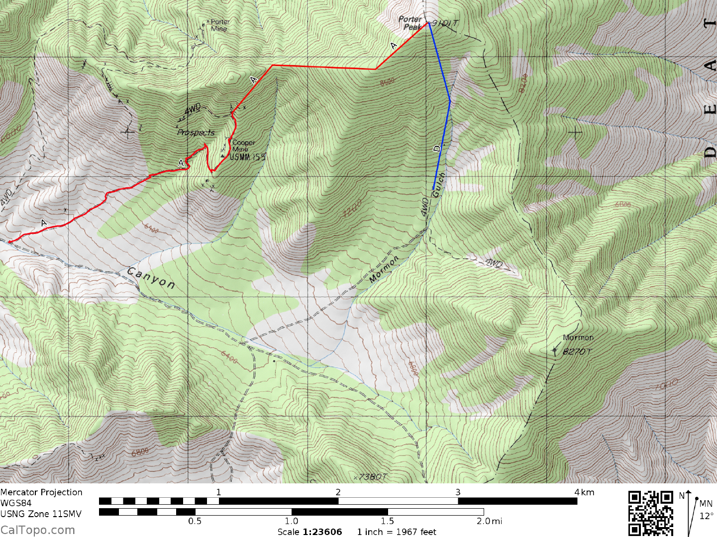
CLIMB/ROUTE A: If you stopped at the 2WD parking spot, hike up the 4WD road to the Cooper Mine.
From
here sidehill NE to the saddle located 0.9 miles SW of the peak at 8000 feet elevation. Head generally E
from here up an easy ridge for 1.0 mile to the summit.
ROUND TRIP STATS/ROUTE A/2WD: 3100 feet elevation gain, 7 miles, 7 hours
ROUND TRIP STATS/ROUTE A/4WD: 2000 feet elevation gain, 4 miles, 4 hours
DRIVE/ROUTE B: Follow DRIVE/ROUTE B directions for Sentinel Peak, Guide No. 2.8.
CLIMB/ROUTE B: Walk W up the canyon for about 2.0 m
iles on a faint use trail to Hungry
Bills Ranch (see
SIDELINES 3), which is nowadays marked by the ruins of crumbling stone walls. From the ranch hike SE
about 300 yards to pick up a very faint trail heading SW. Follow this trail for about 3.0 miles to a saddle
located 0.5 miles N of the peak at 8560+ feet elevation. Walk S from the saddle to the gentle summit of
Porter.
ROUND TRIP STATS/ROUTE B: 5100 feet elevation gain, 11.5 miles, 12 hours
DRIVE/ROUTE C: Follow DRIVE/ROUTE A directions for Sentinel Peak, Guide No. 2.8.
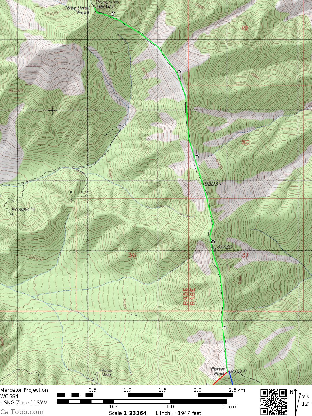
CLIMB/ROUTE C: Follow CLIMB/ROUTE A directions to the top of Sentinel Peak. From the top of
Sentinel hike S along the crest of the Panam
ints for 4.0 m
iles to the summit of Porter Peak. This route is
obviously not practical if your main goal is climbing Porter. However, in conjunction with a trip
up Surprise
Canyon to Sentinel Peak, it might make sense to "bag" Porter at the same time. Following are
2 DEATH VALLEY RANGES GUIDE NO. 2.9
PORTER PEAK (CONTINUED)
the Round Trip Stats for a journey from the top of Sentinel to Porter Peak. Remember that this elevation gain,
mileage and time must be added to the Round Trip Stats of any route up Sentinel Peak.
ROUND TRIP STATS (SENTINEL TO PORTER ONLY)/ROUTE
C: 2300 feet elevation gain, 8 miles, 5-6
hours
DRIVE/ROUTE D: Follow Drive/Route A to the road fork at Stone Corral. Bear right here
and drive 1.3
miles to a fork. Bear left, driving uphill about 1.0 mile on a 4WD road to the 7000 foot level. Park.
CLIMB/ROUTE D: Either hike N up easy slopes to the
summit or NE to the ridgeline, turning left and
following it to the top.
ROUND TRIP STATS/ROUTE D: 2100 feet elevation gain, 2.5 miles, 3 hours
SIDELINES
1. This peak is located within the boundary of Death Valley National Park.
2. The gate at Clair Camp is there because this area is
a patented mining claim and as such is private property.
The owner of the claim has been in negotiations with the BLM to allow public access through Clair Camp.
During the summer of 1991 the gate was kept unlocked, thus providing public access to the upper parts of
Pleasant Canyon. The future status of this gate can change, so you might want to check with the BLM office
in Ridgecrest before planning a trip here. The phone number of the BLM District Office in Ridgecrest is
(619) 375-7125.
3. Ballarat, the small town just down from the mouth of Pleasant Cany
on in Panamint Valley is a place rich in
local history. The town was established in 1897 following the discovery of gold and subsequent development
of the Ratcliff mine in nearby Pleasant Canyon. It got its name from a famous 1850's gold rush camp in
Victoria, Australia. By the end of 1897 the town boasted four saloons, two general stores, two restaurants,
three feed yards, a post office, assay office, hotel and two stage companies offering weekly service. But, as
with most all other boom towns of its day, Ballarat eventually faded away and in 1917 closed its post office
for good.
There were a few local characters that added a touch of color to Ballarat in its hey
day. Chris Wicht, the local
bartender from about 1902 to 1917 was one such legend. Late one night in 1903 while in his bar, Chris was
arguing with a rival suitor for the attention of a Randsburg woman he fancied. The argument
got out of control, Chris pulled his gun and in the ensuing scuffle the other man got the gun and shot Chris in
the backside as he was m
aking a beeline for the back door. Chris Wicht lived in the cabin (which
PORTER PEAK (CONTINUED)
2 DEATH VALLEY RANGES GUIDE NO. 2.9
still bears his name) at the mouth of Surprise Canyon until 1944. Another name associated with Ballarat is
that of Charles Ferge, alias Seldom Seen Slim. Seldom was probably the last of the old time prospectors,
having roamed the desert in search of gold with such legendary figures as Shorty Harris and
Jim Sherlock. A long time resident of Ballarat, he was known to m
any who visited there in the 1950's and
60's. When he died in 1968, his obituary was run in the Los Angeles Times and a large crowd, including a
national television crew attended his funeral at the Ballarat cemetery. His bronze grave marker, which can be
seen at the cemetery carries the following epitaph; "Me lonely? Hell no. I'm half coyote and half wild burro!"
4. Hungry Bill was a Panamint Shoshone who lived in the Death Valley
area during the 1800's. He was
brother to Panamint Tom, the last "pakwinavi" or chief of the tribe. Each year after harvesting pine nuts in the
Panamint Range, the tribe would winter in at least five main villages, one of these being a place called
Puaitungani in Johnson Canyon. This village, now long gone, is the present day site (ruins) of Hungry Bills
Ranch. During the boom days of Panamint City in the 1870's a man named William Johnson moved into the
canyon around Puaitungani and began farming. His idea was to sell fresh fruit and vegetables to the miners
just over the hill. When the Panamint City mines played out, Johnson moved on. The canyon in which he
farmed was later named in his honor.