2 DEATH VALLEY RANGES GUIDE NO. 2.8
SENTINEL PEAK 9634 FEET CLASS 1
MILEAGE: 193 miles of paved road, 5.5 miles of excellent dirt, 3.4 miles of good dirt
DRIVE/ROUTE A: From Trona, CA. drive 23 miles N on the paved Trona-Wildrose Road to the signed
Ballarat Road. Turn right (E) on this excellent dirt road and follow it 3.6 m
iles to the town of Ballarat. As
you drive through Ballarat you'll approach a white mileage sign at the junction of the Ballarat and Wingate
roads (This sign points out direction and mileage to various points of interest in the area.). Turn left (N) and
drive 1.9 miles to the turnoff for Surprise Canyon, marked by a large white rock and a green sign post
"Surprise". Turn right (NE) and drive 3.4 miles to the end of the road near Chris Wicht's (currently Novak's)
Camp. Park.
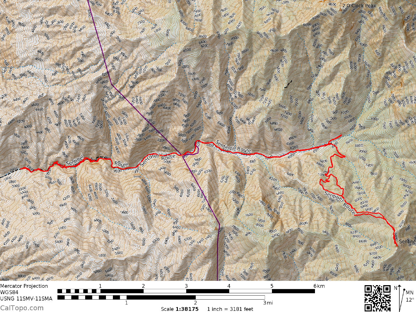
CLIMB/ROUTE A: Hike E up Surprise Canyon for about 1.0 miles to where you can pick up the old road
which heads up to Panam
int City. A flash
flood in the summer of 1984 washed this road out, obliterating
most traces of it in the first mile.
You will have to climb some slippery and awkard rock on the right side of
the falls. There is long step around that some may find difficult. Once past this the route winds in and out of
brush, crossing the creek several times, and often right up the creek itself. You will likely get your feet wet here.
Once on the road, follow it for about 4.0 miles to the historic old silver m
ining town for a total of just over
six miles. For about the last mile you'll see the brick smokestack of the old smelter. From the road just
behind the smokestack scramble up a slope to the Wyoming Mine road which is then followed to the mine.
From here climb the ridge SE for 1.5 miles to the summit. As an alternate, hike about 200 yards E of the
smokestack to the entrance of Magazine Canyon and follow it SE to the summit ridge and the top. This route
is best done as a weekend backpack with an overnight stay at Panamint City, where good water and fine
camping are available (See Sidelines 3 for map of Panamint City). Please leave this historic area undisturbed
for others to enjoy.
ROUND TRIP STATS/ROUTE A: 7000+ feet elevation gain, 16-18 miles, 14 hours
DRIVE/ROUTE B: From Shoshone, CA. drive N
1.5 miles on State Route 127 to its junction with State
Route 178. Turn left (W) on State Highway 178 and drive 29.1 miles to the signed West Side Road, en route
entering Death Valley National Park. Turn left on the West Side Road (excellent dirt) and follow it 15.0 miles
to a signed, poor dirt road heading left (W) toward Johnson Canyon. This rough road climbs the alluvial fan
for 6.0 miles before reaching the mouth of Johnson Canyon. 2.5 miles beyond the canyon mouth is a fork.
Bear right, up the N fork, driving about 1.0 mile to the end of the road at a spring. Park.
CLIMB/ROUTE B: Walk W up the canyon for about 2.0 miles on a faint use trail
to
Hungry Bills Ranch,
which is nowadays marked by the ruins of crumbling stone walls. Hike generally WNW
from the ranch on a faint use trail for about 3.0 miles to Panamint Pass. At the pass turn left (SW) and climb the
ridge 1.0 miles to the summit. This route is best done as a weekend backpack. You must carry all your own water
on this route.
ROUND TRIP STATS/ROUTE B: 5700 feet elevation gain, 12 miles, 12 hours
DRIVE/ROUTE C: Follow the DRIVE/ROUTE A instructions for Porter Peak, Guide No. 2.9.
SENTINEL PEAK (CONTINUED)
2 DEATH VALLEY RANGES GUIDE NO. 2.8
CLIMB/ROUTE C: Follow the CLIMB/ROUTE A instructions for Porter Peak, Guide No. 2.9. From the top
of Porter Peak hike N along the crest of the Panamints for 4.0 miles to the summit of Sentinel Peak. Return
the same way. This is probably the easiest way to day hike Sentinel Peak plus get Porter thrown in as a bonus.
ROUND TRIP STATS/ROUTE C: 4000 feet elevation gain, 12 miles, 9 hours
SIDELINES
1. This peak is located within the boundary of Death Valley National Park.
2. High assay silver and copper bearing ores were discovered in 1873 near the head of Surprise Canyon by
Richard Jacobs
and two of his companions. At the time, Jacobs and company were hiding out in the canyon,
fugitives from the law because of a Wells Fargo robbery they committed a month earlier. Through a strange
set of circumstances the bandits obtained immunity from prosecution by repaying their "loan" to Wells Fargo.
Acting as intermediaries between the parties, two United States senators from Nevada, John P. Jones and
William Stewart secured the freedom of the outlaws in exchange for interest in their Surprise Canyon mining
claim.
Starting off slowly, within two years the population of Panam
int City was over 1500 people. The town
boasted som
e 200 houses, numerous saloons, a red light district, stores, a bank and even a local newspaper.
Because of its location in the narrow canyon, the city was laid out along one street a mile long with nearly
1000 feet of elevation difference between the upper and lower ends! There simply wasn't room to expand in
any other direction.
Along with some other boom towns of that era, Panamint City
was known for its lawless nature. In
fact, it had
such a bad reputation that when Wells Fargo was asked to establish freight service to and from the town, they
respectfully declined. This was a problem for the mine owners because silver bullion shipments out of the
canyon were frequently ambushed in the valley below. A solution to this problem was finally found when
Senator Stewart started having the silver from his mines cast into 750 pound balls. The sheer weight of these
castings made a quick getaway impossible for the robbers, thus solving the problem of overland
transportation.
Extraction of ore eventually started becoming more difficult because of the nature of the quartz veins and the
hardness of the rock encountered. This coupled
with a stock ma
rket crash in May 1877 brought Panamint
City to its knees, never to fully recover again. Altogether $2.5 million in silver ore was recovered from the
Panamint City mines before their collapse.
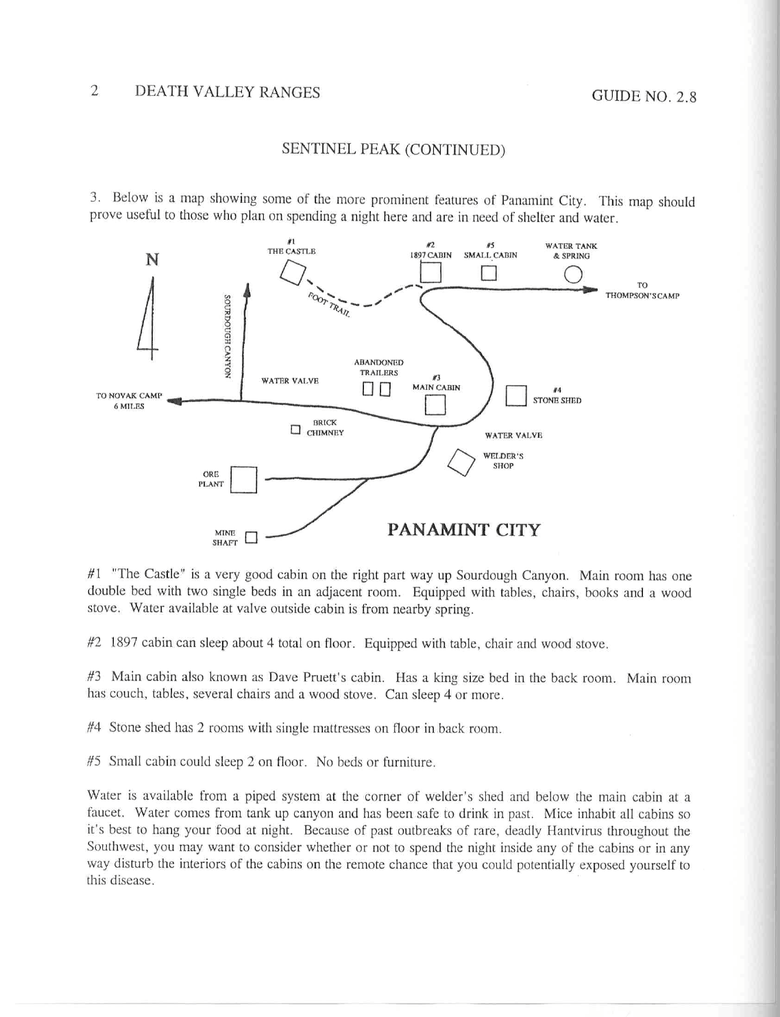
3. Below is a map showing some of the more prominent features of Panam
int City. This m
ap should prove
useful to those who plan on spending a night here and are in need of shelter and water.
SENTINEL PEAK (CONTINUED)
2 DEATH VALLEY RANGES GUIDE NO. 2.8
#1 "The Castle" is a very good cabin on the right part way up Sourdough Canyon. Main room has one
double bed with two single beds in an adjacent room. Equipped with tables, chairs, books and a wood stove.
Water available at valve outside cabin is from nearby spring.
#2 1897 cabin can sleep about 4 total on floor. Equipped with table, chair and wood stove.
#3 Main cabin also known as Dave Pruett's cabin. Has a king size bed in the back room
. Main room has
couch, tables, several chairs and a wood stove. Can sleep 4 or more.
#4 Stone shed has 2 room
s with single mattresses on floor in back room.
#5 Small cabin could sleep 2 on floor. No beds or furniture.
Water is available from a piped system at the corner of welder's shed and below the
main cabin at a faucet.
Water com
es from tank up canyon and has been safe to drink in past. Mice inhabit all cabins so it's best to
hang your food at night. Because of past outbreaks of rare, deadly Hantvirus throughout the Southwest, you
may want to consider whether or not to spend the night inside any of the cabins or in any way disturb the
interiors of the cabins on the remote chance that you could potentially exposed yourself to this disease.
Note: the piped system had been destroyed (by vandals?) as of Fall, 2016. Water must be obtained directly from
the tank up canyon. It was flowing and clear, but probably should be treated. The tank no longer appears to
hold any appreciable water.
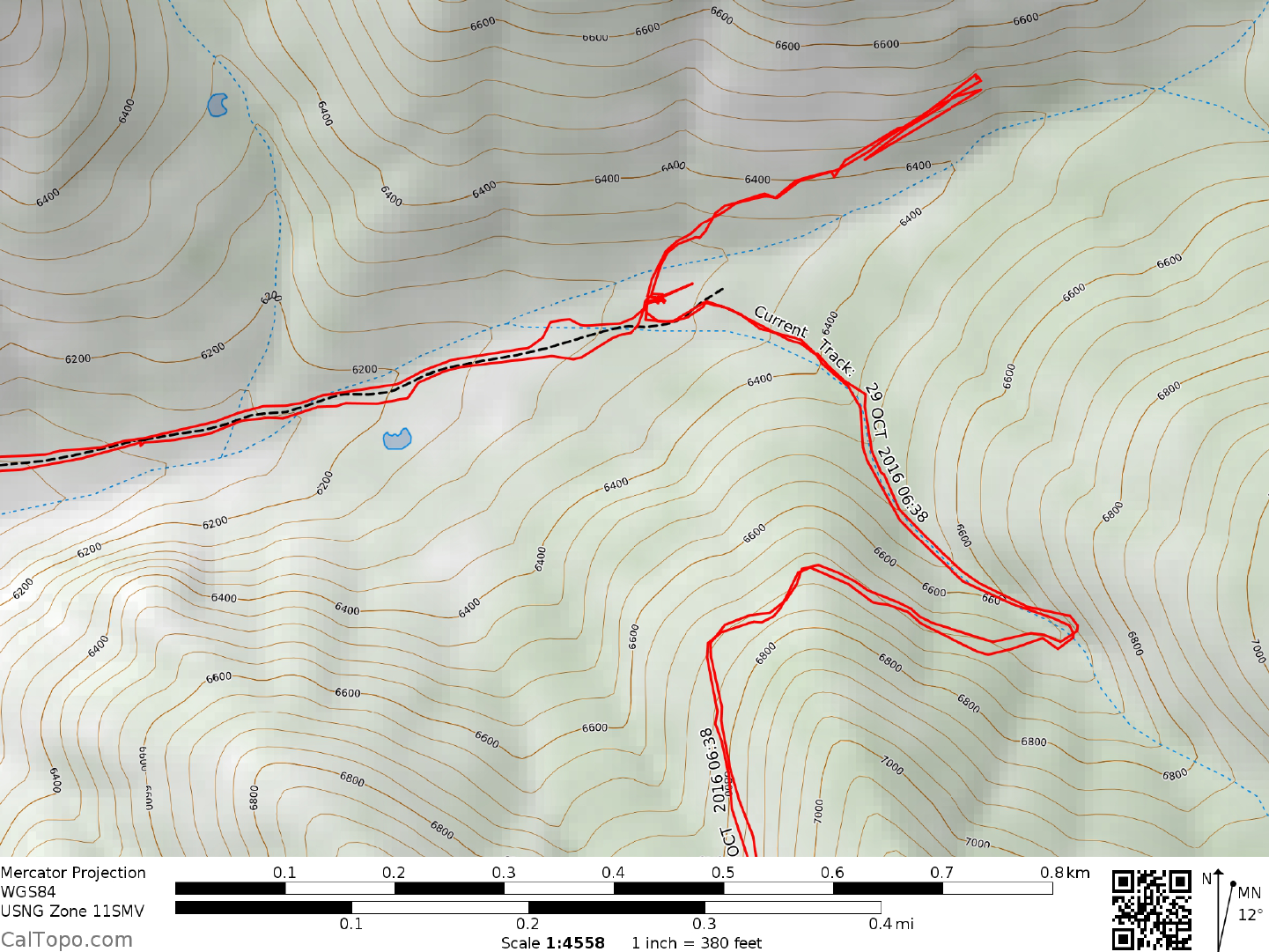
N 36° 07' 11.3"
W 117° 05' 31.5"
Water tank location --------->