Guide
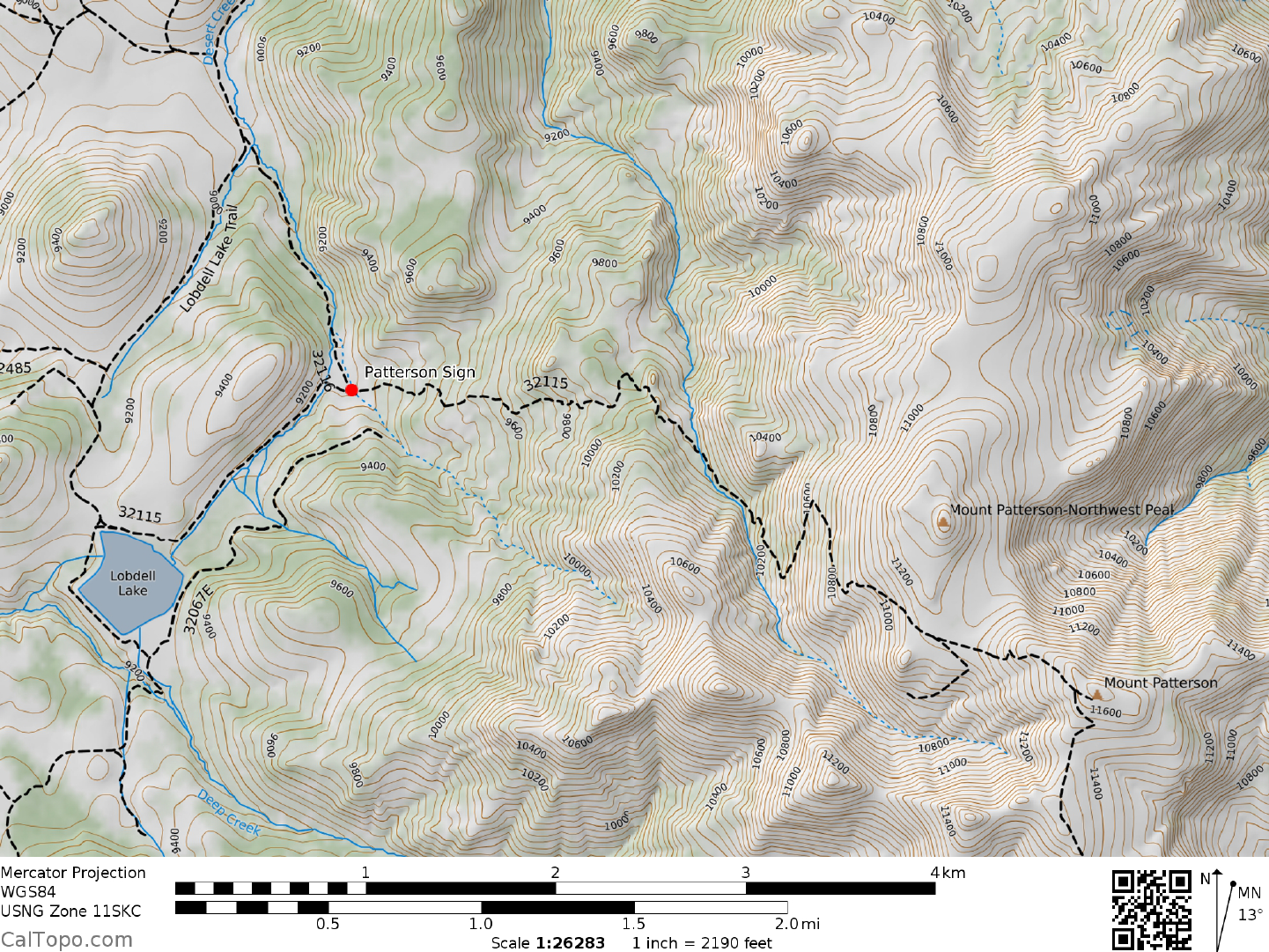
DRIVE/ROUTE A (LOBDELL LAKE): From Bridgeport, CA. drive 14.8 miles N on US Highway 395. Turn right (N) here on the signed, Burcham Flat Road (good dirt) and follow it as it turns E then N for 4.3 miles to a junction. Turn right on a good dirt road signed "067", crossing the south fork of Cottonwood Creek in 2.5 m iles. From the creek crossing drive 3.7 miles to a fork at Lobdell Lake (9100 feet elevation). Bear left here, driving N along the W side of the lake for 2.1 miles to the junction with a poor dirt road. Turn right (SE) and continue to the Patterson Forest Service sign (see the map below). Park. NOTE: During the spring, mud and/orsnow from below Lobdell Lake to the road's end could make this a 4WD approach.
CLIMB/ROUTE A: Walk SE up the closed jeep road (actually more like a trail further up) about 2.5 miles to a point just 100 yards S of the summit. Turn left (N) here and walk to the top. ROUND TRIP STATS/ROUTE A: 1600 feet elevation gain, 5 miles, 2-3 hours
DRIVE/ROUTE B (NUGENT CABIN): Entering Bridgeport, CA. on US Highway 395 from the south, turn right (N) on State Route 182 and drive 12.4 m iles to State Route 338, en route crossing the state line into Nevada. Make a left on State Route 338 and drive about 9.5 miles to a dirt road heading SW (This road is about 0.5 miles before the signed Sweetwater Summit). Turn left here on signed Forest Service dirt road "069" and drive 5.3 miles, crossing the state line back into California and up Sweetwater Canyon to road's end at the Nugent Cabin near the 8120 foot elevation level. Park. NOTE: Heavy spring rains can make this road impassable.
CLIMB/ROUTE B: Hike up Sweetwater Canyon about 1.0 mile, following it SSW then S to the base of a N- S ridge (UTM 009588). Climb this ridge nearly 1.5 miles to a saddle (UTM 009568) just SW of point 10943. From here follow a westerly running ridge 1.5 miles to the summit, en route passing over point 10831. ROUND TRIP STATS/ROUTE B: 3600 feet elevation gain, 8 miles, 5-6 hours
SIDELINES
- Mt Patterson, the highpoint of the Sweetwater Range, was named possibly for James H. Patterson, a native of Ohio who settled in nearby Big Meadows around 1867.
- In June of 2014, the roads were open in their entirety. There was evidence that some had driven the entire distance to the summit.
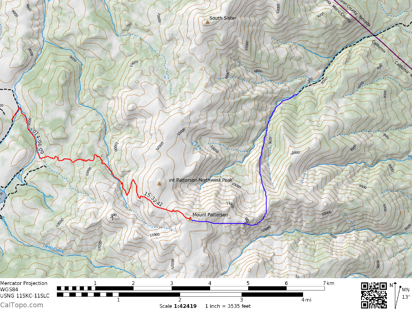
- The map shows my route (in red) minus my side trip to Wheeler. One's starting point may be determined by either how willing you are to hike vs. the condition of the road, or where the best place to camp is to be found.
- One interpretation of the B route is shown in Blue.
- Camping spots may be found in several places. One spot suitable for multiple vehicles is found at the intersec- tion of the two roads, 32115 and 32116. See the location of the red dot on the map below.